


045649 - TEMPLE COUNTY Voting District, Carroll County, Georgia
About
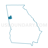
Outline

Summary
| Unique Area Identifier | 560467 |
| Name | 045649 - TEMPLE COUNTY Voting District |
| County | Carroll County |
| State | Georgia |
| Area (square miles) | 21.38 |
| Land Area (square miles) | 20.98 |
| Water Area (square miles) | 0.40 |
| % of Land Area | 98.11 |
| % of Water Area | 1.89 |
| Latitude of the Internal Point | 33.76135060 |
| Longtitude of the Internal Point | -85.01267350 |
Maps


Graphs
Select a template below for downloading or customizing gragh for 045649 - TEMPLE COUNTY Voting District, Carroll County, Georgia


Neighbors
Neighoring Voting District (by Name) Neighboring Voting District on the Map
- 0451122 - SANDHILL Voting District, Carroll County, GA
- 0451152 - CENTER POINT Voting District, Carroll County, GA
- 045640 - V R COUNTY SOUTH Voting District, Carroll County, GA
- 045641 - V R COUNTY NORTH Voting District, Carroll County, GA
- 045650 - TEMPLE CITY Voting District, Carroll County, GA
- 14302 - BREMEN Voting District, Haralson County, GA
- 14305 - CORINTH Voting District, Haralson County, GA
- 14310 - SEVENTH Voting District, Haralson County, GA
- 22308 - UNION ELEMENTARY Voting District, Paulding County, GA
Top 10 Neighboring County Subdivision (by Population) Neighboring County Subdivision on the Map
- Villa Rica CCD, Carroll County, GA (20,222)
- Yorkville CCD, Paulding County, GA (17,016)
- Bremen CCD, Haralson County, GA (12,999)
- Temple CCD, Carroll County, GA (11,728)
- Buchanan CCD, Haralson County, GA (7,592)
Top 10 Neighboring Place (by Population) Neighboring Place on the Map
Top 10 Neighboring Unified School District (by Population) Neighboring Unified School District on the Map
- Paulding County School District, GA (142,324)
- Carroll County School District, GA (86,094)
- Haralson County School District, GA (22,598)
Top 10 Neighboring State Legislative District Lower Chamber (by Population) Neighboring State Legislative District Lower Chamber on the Map
- State House District 17, GA (79,395)
- State House District 68, GA (65,624)
- State House District 18, GA (52,188)
Top 10 Neighboring State Legislative District Upper Chamber (by Population) Neighboring State Legislative District Upper Chamber on the Map
- State Senate District 30, GA (212,492)
- State Senate District 31, GA (204,694)
- State Senate District 28, GA (191,899)
Top 10 Neighboring 111th Congressional District (by Population) Neighboring 111th Congressional District on the Map
Top 10 Neighboring Census Tract (by Population) Neighboring Census Tract on the Map
- Census Tract 1204, Paulding County, GA (17,016)
- Census Tract 9102, Carroll County, GA (11,728)
- Census Tract 9101.04, Carroll County, GA (9,273)
- Census Tract 104, Haralson County, GA (7,804)
- Census Tract 9101.03, Carroll County, GA (5,020)
- Census Tract 103.01, Haralson County, GA (3,621)